Dún Chaoin - An Fheothanach
(Dunquin - Feohanagh)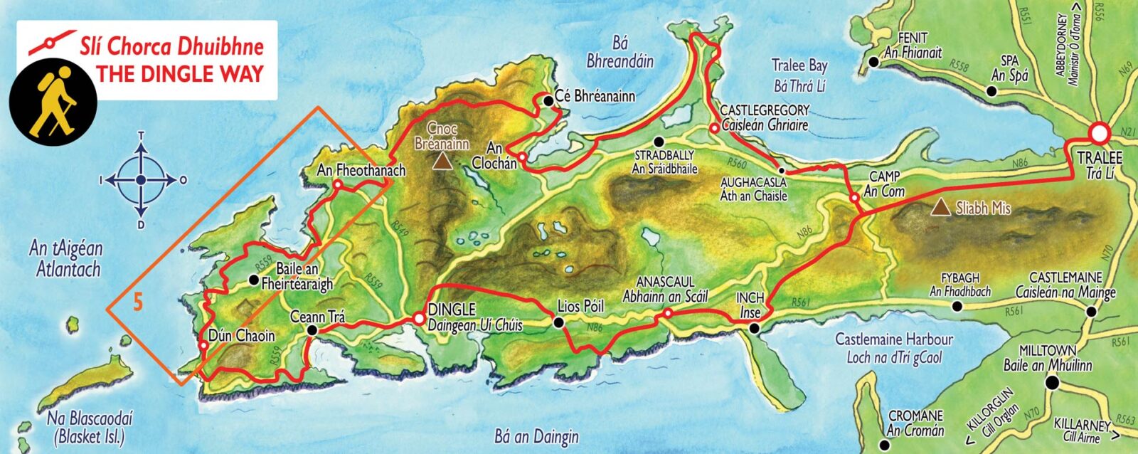
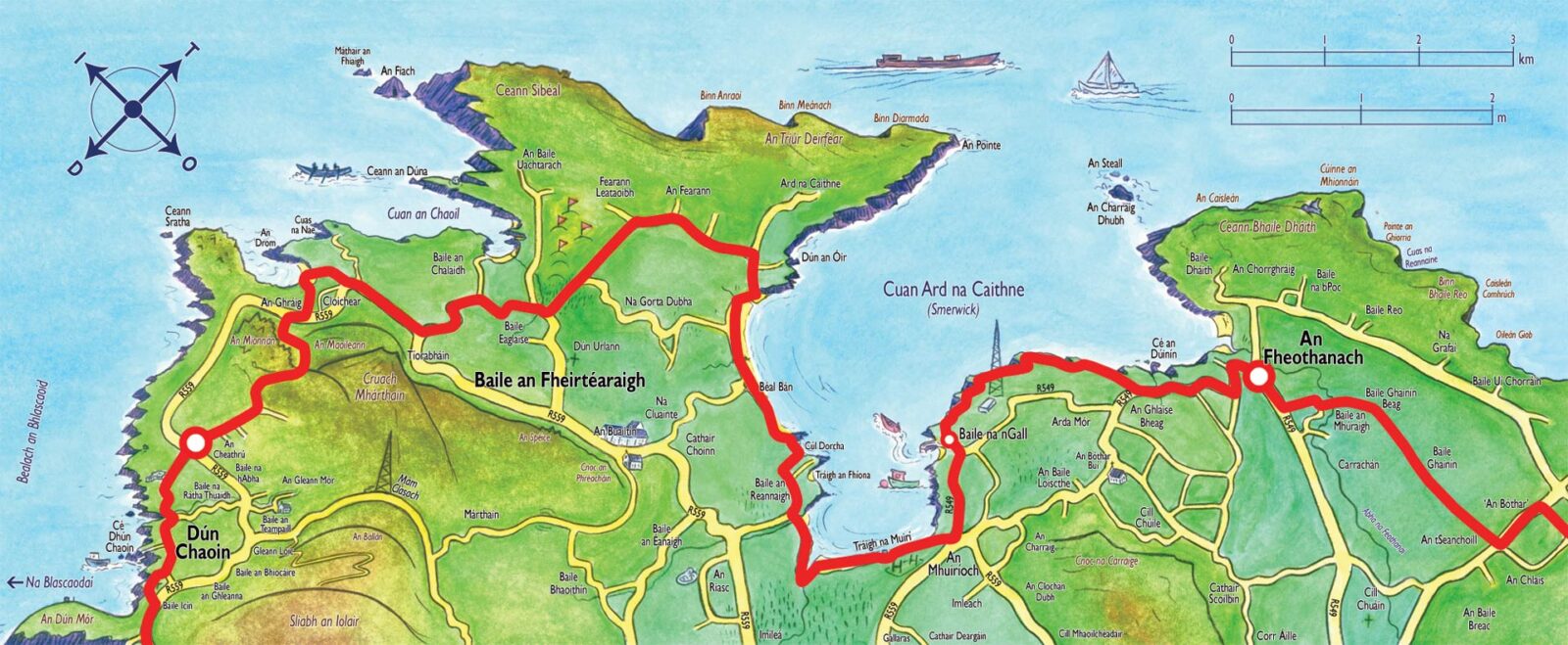
Map of the Dunquin to Feothanach section of the Dingle Way
Distance: 20 km | Ascent: 125 m | Time: 5—7 hrs | Grade: Easy
Leaving Dún Chaoin at An Óige Youth Hostel, head uphill due north where the Dingle Way soon turns left around a wide bend then an almost immediate right into a gravel path. Ahead is the scattered outline of volcanic Mionnán Mór beyond which opens up to yet another wonderful vista dominated by Mt. Brandon, the Three Sisters, Smerick Harbour and Sybil Point. Depending on the weather and the time of year the ground underfoot here can be quite wet in areas so care must be taken. The route then descends and joins back up with the main road, going right on the R559, passing Louis Mulcahy’s famous pottery. After 500m turn left down a narrow road, where care must be taken in the summer months as the hedgerows can become quite overgrown. At a right bend continue on until you come in to overlook the secluded beach at Clogher.
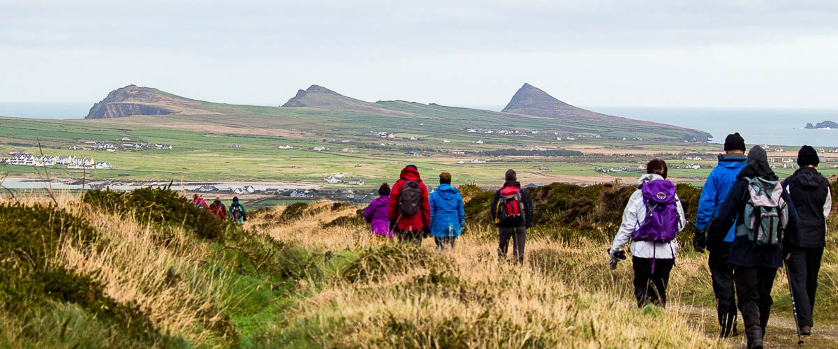
Walkers in Baile an Chalaidh with the Three Sisters in the distance
After passing the small picturesque Clochar Beach, which offers views of Inis Tuaisceart (An Fear Marbh/The Dead Man) follow the narrow road back up to the main road for a short period. Then taking a minor road to the left proceed in a north-easterly direction to the east side of Ceann Sibéal golf course. At the end of this road you will come to a T-junction and you veer right and just a few meters along the road you will take a left following the road. You will follow the road to the right at its natural end and from there you will carry on and take another right towards Béal Bán Strand. To your left at the northern side of the strand is Dún an Óir, originally the site of a promontory fort where 600 Italian, Spanish and Irish men were massacred by Elizabethan Crown Forces during the Desmond Rebellion in 1580.
Smerick Harbour will be the vista to your left for the next 6km of the walk across the beach. Smerwick, a word which is believed to be of Norse origin, meaning Butter Harbour where a huge trade was done in butter going back to Viking times. On this streach of walk on the Dingle Way you will bypass Baile an Fheirtéaraigh, the largest settlement west of Dingle, which has a local museum, pubs, restaurant, church and school. This first section of beach brings you 1.4km along before you leave the beach through a gap in the dunes, bearing left along the cliff top, following the road and the signs and veering left across to the beach again. You will cross a small stream after descending to the beach.
Before you reach Muiríoch, where the walk meets the road again, you will pass close to the south of Gallarus Oratory, a dry-stone oratory which is the most characteristic ancient monument of the peninsula which dates from 7-12th century and also Gallarus Castle, a recently renovated 15th century Norman tower house.
After reaching the road from the beach you will take a left towards the small fishing port of Baile na nGall, taking a left into the village. You will see a path to the left after the village taking in a larger section of cliff-walk, passing a large radio mast belonging to Raidió na Gaeltachta, a station that broadcasts through the Irish language, before it starts to head back inland, rejoining the road at an Ghlaise Bheag. Parts of this cliff walk can be very marshy and slightly flooded depending on weather so care must be taken. Once you reach the main road again you will turn left and walk along the roadside until you reach An Cúinne pub in Feothanach where this section of the walk ends. Brandon Mountain to the north now dominates the next section of the Dingle Way.
Looped Walks
Lúb na Cille, Dunquin
Distance: 5 km | Ascent: 130 m | Time: 1.5 – 2 hrs | Grade: Easy
This looped walk starts and finishes in the Blasket Centre car park in Dún Chaoin. It offers beautiful Atlantic views of the Blaskets and surrounding areas. It is a moderate walk suitable for people of varying fitness levels and will take between one hour and one hour and a half. The initial part is uphill but is easy enough after that. There are about half a dozen stiles to climb. The final bit is along a cliff so you need to be attentive if walking with young children
Cuas na nEighe Walk, Clogher
Distance: 2.9 km | Time: 1 hrs | Grade: Easy
This is a cliff top walk of under two miles which begins and finishes at the car park above Clochar Beach about eight miles west of Dingle. It takes in spectacular sea views and the surrounding countryside and headlands. The walk is flat and has three or four stiles. Easy way-marked way (Blue arrows on a white background)